
Climate and Weather—Sample Online Research Project
Look! Up in the sky! It's a bird! It's a plane! Well, actually,
it's a cumulus cloud in the shape of a swan.
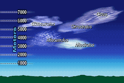
As you now know, clouds come in many sizes and shapes. The
major types, like cumulus, cirrus and stratus, are easy to
identify. It's those combination clouds that are a little
bit harder to recognize. You may recall some from the video
lesson—those with prefixes based on altitude—the
alto- and cirro- clouds. Remember them? Or how about the nimbo-
variety?
 A
cloud catalog may help you in your effort to identify clouds.
What is a cloud catalog, you may wonder? Well, quite simply,
it's kind of like any mail-order catalog you've seen. This
one, though, consists of photos and brief descriptions of
clouds instead of products. A
cloud catalog may help you in your effort to identify clouds.
What is a cloud catalog, you may wonder? Well, quite simply,
it's kind of like any mail-order catalog you've seen. This
one, though, consists of photos and brief descriptions of
clouds instead of products.
You are hereby challenged to research
cloud varieties online. As you come across each new cloud
type, save a picture of it on your hard disk and write a descriptive
caption for the photo. Below is a sample to get you started.
 |
| Altocumulus clouds exist
in the middle altitudes of the troposphere (5-10
km). These clouds typically are a few kilometers
thick and often are opaque enough to dim the sun
considerably. Altocumulus clouds in the morning
may warn of late day thunderstorms. |
|
When you've competed your research, put all the images and
captions together in a small booklet organized in a logical
manner of your choosing.
Here are some keywords and links to help you on your quest.
Be sure to put keyword phrases in quotes.
Keywords
Cloud catalog; cloud types; cumulus cloud; cirrus cloud; stratus
cloud; stratocumulus; cirrocumulus; cirrostratus; altocumulus;
altostratus; nimbostratus; cumulonimbus
Links
http://vortex.plymouth.edu/clouds.html
http://ww2010.atmos.uiuc.edu/(Gh)/guides/mtr/cld/cldtyp/home.rxml
http://www.ccrc.sr.unh.edu/~stm/AS/Weather_Toolbox/Cloud_Classification.html
Back to the top… 
|